
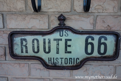
Route 66 - Roadmap - Kansas
The following towns you pass through on Route 66 through Kansas
Galena – Riverton – Baxter Springs
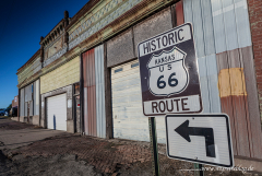
Galena
East of Joplin is the border to Kansas. Follow the Route 66 and drive up the left turn onto W Old Route 66 you reach Galena on Main Street / Front Street. To the right is the “Cars on Route 66”, an old gas station, on the left the “Steffelback House,” a former brodello. Follow the Main Street through the town.
Riverton
After you’ve passed through Galena, follow U.S. 66 and W 7th Street continue straight approximately 4 miles you will reach already Riverton, KS. Riverton is much smaller than Galena and has no special Route 66 attractions.
Baxter Springs
A mile behind Riverton is a roundabout, leave this at the 2nd exit and drive to the SE Beasley Road. Follow the road across the Rainbow Bridge, which crosses the Brush Creek. After the bridge the road is called SE 50th Street. Follow the road until it meets W North 10th Street. Turn left, you are now on Highway 69 (Military Ave.) After a few miles you reach Baxter Springs, KS
Galena, Kansas – Baxter Springs, Kansas
Bigger Map
The Route 66 in Kansas is a total of 13 miles or 29 kilometers long
All data I give to you has been researched to the best of my knowledge and belief. Nevertheless, to me, of course, be a mistake. In addition to my information, please use always current maps or guidebooks.